Datei:Nevados Casiri.jpg
Es ist keine höhere Auflösung vorhanden.
Nevados_Casiri.jpg (640 × 449 Pixel, Dateigröße: 77 KB, MIME-Typ: image/jpeg)
![]()
Diese Datei und die Informationen unter dem roten Trennstrich werden aus dem zentralen Medienarchiv Wikimedia Commons eingebunden.
![]()
Beschreibung
| Beschreibung |
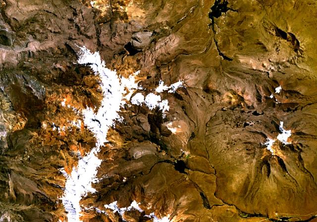
English: The three roughly E-W-trending cones at the center of this NASA Landsat image (with north to the top) form the Nevados Casiri complex, the southernmost Holocene volcano in Perú. A fourth cone, the youngest of the complex, lies on the SE side and was the source of two fresh Holocene lava flows, which form the dark-colored lobes visible south of the massif. Two sulfur mines have been opened on the NW and SE flanks of Nevados Casiri. |
| Datum | Unbekanntes Datum |
| Quelle | http://www.volcano.si.edu/world/volcano.cfm?vnum=1504-06-&volpage=photos&photo=114097 |
| Urheber | NASA Landsat7 image (worldwind.arc.nasa.gov) |
Lizenz
| Diese Datei ist gemeinfrei (Public Domain), da es sich um einen Screenshot der NASA-Software World Wind handelt, in der ein gemeinfreier Datensatz wie Blue Marble, MODIS, Landsat, SRTM, USGS oder GLOBE verwendet wird.
|
 |
Dateiversionen
Klicke auf einen Zeitpunkt, um diese Version zu laden.
| Version vom | Vorschaubild | Maße | Benutzer | Kommentar | |
|---|---|---|---|---|---|
| aktuell | 08:58, 20. Jul. 2010 | | 640 × 449 (77 KB) | Michael Metzger | {{Information |Description={{en|1=The three roughly E-W-trending cones at the center of this NASA Landsat image (with north to the top) form the Nevados Casiri complex, the southernmost Holocene volcano in Perú. A fourth cone, the youngest of the complex |
Dateiverwendung
Die folgende Seite verwendet diese Datei:
Globale Dateiverwendung
Die nachfolgenden anderen Wikis verwenden diese Datei:
- Verwendung auf arz.wiki.x.io
- Verwendung auf en.wiki.x.io
- Verwendung auf es.wiki.x.io
- Verwendung auf eu.wiki.x.io
- Verwendung auf fa.wiki.x.io
- Verwendung auf lld.wiki.x.io
- Verwendung auf no.wiki.x.io
- Verwendung auf pl.wiki.x.io
- Verwendung auf pt.wiki.x.io
- Verwendung auf qu.wiki.x.io
Weitere globale Verwendungen dieser Datei anschauen.