|
|
Bezeichnung
|
Bild
|
Datum der Eintragung
|
Lage
|
Stadt
|
Beschreibung
|
| 1
|
Adamson House
|

|
28. Okt. 1977
|
23200 W. Pacific Coast Highway
34° 2′ 4″ N, 118° 40′ 42″ W34.034444444444-118.67833333333
|
Malibu
|
|
| 2
|
Adobe Flores
|
|
18. Juni 1973
|
1804 Foothill St.
34° 7′ 11″ N, 118° 8′ 41″ W34.119722222222-118.14472222222
|
South Pasadena
|
|
| 3
|
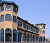
Alexander Theatre
|
Datei:Alex-02.jpg
|
16. Feb. 1996
|
216 N. Brand Blvd.
34° 8′ 57″ N, 118° 15′ 12″ W34.149166666667-118.25333333333
|
Glendale
|
|
| 4
|
Anderton Court Shops
|

|
14. Mai 2004
|
332 N.Rodeo Dr.
34° 4′ 6″ N, 118° 24′ 3″ W34.068333333333-118.40083333333
|
Beverly Hills
|
|
| 5
|
Antelope Valley Indian Museum State Historic Park
|
|
26. Feb. 1987
|
15701 East Ave.
34° 39′ 1″ N, 117° 50′ 56″ W34.650277777778-117.84888888889
|
Lancaster
|
|
| 6
|
Ard Eevin
|
|
21. Nov. 2006
|
851 W. Mountain St.
|
Glendale
|
|
| 7
|
Atchison, Topeka, and Santa Fe Railroad Station (Claremont, Kalifornien)
|

|
15. Juli 1982
|
110 W. 1st St.
34° 5′ 39″ N, 117° 42′ 58″ W34.094166666667-117.71611111111
|
Claremont
|
|
| 8
|
Torrance High School Auditorium
|

|
13. Okt. 1983
|
2200 W. Carson
33° 49′ 48″ N, 118° 19′ 11″ W33.83-118.31972222222
|
Torrance
|
|
| 9
|
Aztec Hotel
|
|
22. Mai 1978
|
311 W. Foothill Blvd.
34° 9′ 6″ N, 118° 0′ 18″ W34.151666666667-118.005
|
Monrovia
|
|
| 10
|
Azusa Civic Center
|

|
21. Feb. 2002
|
213 Foothill Blvd.
34° 8′ 3″ N, 117° 54′ 18″ W34.134166666667-117.905
|
Azusa
|
|
| 11
|
Jonathan Bailey House
|

|
29. Aug. 1977
|
13421 E. Camilla St.
33° 59′ 5″ N, 118° 1′ 53″ W33.984722222222-118.03138888889
|
Whittier
|
|
| 12
|
Beverly Hills Women's Club
|

|
4. Okt. 2006
|
1700 Chevy Chase Dr.
34° 5′ 9″ N, 118° 25′ 47″ W34.085833333333-118.42972222222
|
Beverly Hills
|
|
| 13
|
Beverly Wilshire Hotel
|

|
12. Juni 1987
|
9528 Wilshire Blvd.
34° 4′ 1″ N, 118° 23′ 20″ W34.066944444444-118.38888888889
|
Beverly Hills
|
|
| 14
|
Casa de Parley Johnson
|
|
20. März 1986
|
7749 Florence Ave.
33° 57′ 24″ N, 118° 7′ 57″ W33.956666666667-118.1325
|
Downey
|
|
| 15
|
Cedar Avenue Complex
|
|
30. Sep. 1993
|
44843 (44855), 44845 and 44851 Cedar Ave., 606 Lancaster Blvd. und Old Jail (no address)
34° 41′ 58″ N, 118° 8′ 20″ W34.699444444444-118.13888888889
|
Lancaster
|
|
| 16
|
Charmont Apartments
|

|
25. Juli 1996
|
330 California Ave.
34° 1′ 12″ N, 118° 29′ 58″ W34.02-118.49944444444
|
Santa Monica
|
|
| 17
|
Christmas Tree Lane
|

|
13. Sep. 1990
|
Santa Rosa Ave. between Woodbury Ave. and Altadena Dr.
|
Altadena
|
|
| 18
|
Citizens Publishing Company Building
|
|
12. Feb. 1987
|
9355 Culver Blvd.
34° 1′ 31″ N, 118° 23′ 35″ W34.025277777778-118.39305555556
|
Culver City
|
|
| 19
|
City Hall-City of Burbank
|

|
18. Apr. 1996
|
275 E. Olive Ave.
34° 10′ 55″ N, 118° 18′ 27″ W34.181944444444-118.3075
|
Burbank
|
|
| 20
|
Clarke Estate
|
|
4. Jan. 1990
|
10211 Pioneer Blvd.
33° 56′ 36″ N, 118° 4′ 52″ W33.943333333333-118.08111111111
|
Santa Fe Springs
|
|
| 21
|
Club Casa Del Mar
|

|
29. Sep. 2000
|
1910 Ocean Ave.
34° 0′ 23″ N, 118° 29′ 25″ W34.006388888889-118.49027777778
|
Santa Monica
|
|
| 22
|
Colonial House
|

|
15. Apr. 1982
|
1416 N. Havenhurst Dr.
34° 5′ 45″ N, 118° 21′ 35″ W34.095833333333-118.35972222222
|
West Hollywood
|
|
| 23
|
Cooper Arms
|
|
28. Dez. 2000
|
455 E. Ocean Blvd.
33° 46′ 1″ N, 118° 11′ 13″ W33.766944444444-118.18694444444
|
Long Beach
|
|
| 24
|
Crank House
|
|
23. Juli 1997
|
2186 Crary St.
34° 10′ 22″ N, 118° 6′ 14″ W34.172777777778-118.10388888889
|
Altadena
|
|
| 25
|
Culver Hotel
|

|
14. Apr. 1997
|
9400 Culver Blvd.
34° 1′ 24″ N, 118° 23′ 38″ W34.023333333333-118.39388888889
|
Culver City
|
|
| 26
|
James Daniel Derby House
|
|
14. Dez. 1978
|
2535 E. Chevy Chase Dr.
34° 9′ 41″ N, 118° 12′ 38″ W34.161388888889-118.21055555556
|
Glendale
|
|
| 27
|
DeWenter Mansion, Guest House and Grounds
|
|
5. Nov. 1992
|
6100 Brydon Rd.
34° 9′ 7″ N, 117° 45′ 23″ W34.151944444444-117.75638888889
|
La Verne
|
|
| 28
|
Diamond Apartments
|
|
26. März 1992
|
321 Diamond St.
33° 50′ 39″ N, 118° 23′ 16″ W33.844166666667-118.38777777778
|
Redondo Beach
|
|
| 29
|
Doheny Estate/Greystone Mansion
|

|
23. Apr. 1976
|
905 Loma Vista Dr.
34° 5′ 31″ N, 118° 24′ 1″ W34.091944444444-118.40027777778
|
Beverly Hills
|
|
| 30
|
Dominguez Ranch Adobe
|
|
28. Mai 1976
|
18127 S. Alameda St.
33° 52′ 1″ N, 118° 13′ 0″ W33.866944444444-118.21666666667
|
Compton
|
|
| 31
|
Edison Historic District
|

|
13. Aug. 1986
|
611, 637, and 500 blk. of W. Second St.
34° 3′ 28″ N, 117° 45′ 13″ W34.057777777778-117.75361111111
|
Pomona
|
|
| 32
|
El Molino Viejo
|

|
6. Mai 1971
|
1120 Old Mill Rd.
34° 7′ 32″ N, 118° 7′ 37″ W34.125555555556-118.12694444444
|
San Marino
|
Wassergetriebene Getreidemühle, die um 1816 erbaut wurde; ältestes erhaltenes Gewerbebauwerk in Südkalifornien
|
| 33
|
Episcopal Church of the Ascension (Sierra Madre, California)
|
|
19. Aug. 1977
|
25 E. Laurel Ave.
34° 9′ 58″ N, 118° 3′ 4″ W34.166111111111-118.05111111111
|
Sierra Madre
|
|
| 34
|
Gen. Charles S. Farnsworth County Park
|
|
7. Feb. 1997
|
568 E. Mt. Curve Ave.
34° 11′ 59″ N, 118° 7′ 54″ W34.199722222222-118.13166666667
|
Altadena
|
|
| 35
|
Fern Avenue School
|
|
20. Feb. 1992
|
1314 Fern Ave.
33° 50′ 6″ N, 118° 19′ 52″ W33.835-118.33111111111
|
Torrance
|
|
| 36
|
First National Bank of Long Beach
|

|
13. Sep. 1990
|
101-125 Pine Ave.
33° 46′ 6″ N, 118° 11′ 30″ W33.768333333333-118.19166666667
|
Long Beach
|
|
| 37
|
Peter Gano House
|
|
15. Sep. 1983
|
718 Crescent Ave.
33° 20′ 34″ N, 118° 19′ 20″ W33.342777777778-118.32222222222
|
Avalon
|
|
| 38
|
Garfield House
|
|
24. Apr. 1973
|
1001 Buena Vista St.
34° 7′ 14″ N, 118° 9′ 21″ W34.120555555556-118.15583333333
|
South Pasadena
|
|
| 39
|
Glendale Southern Pacific Railroad Depot
|
Datei:GlendalStationStreetside.jpg
|
2. Mai 1997
|
Kreuzung von Gardena Ave. un W. Cerritos Ave.
34° 7′ 25″ N, 118° 15′ 29″ W34.123611111111-118.25805555556
|
Glendale
|
|
| 40
|
Glendale Young Men's Christian Association (YMCA)
|

|
21. Okt. 1994
|
140 N. Louise St.
34° 8′ 52″ N, 118° 15′ 4″ W34.147777777778-118.25111111111
|
Glendale
|
|
| 41
|
Glendora Bougainvillea
|
|
7. Feb. 1978
|
Bennett and Minnesota Aves.
34° 8′ 27″ N, 117° 51′ 34″ W34.140833333333-117.85944444444
|
Glendora
|
|
| 42
|
Green-Rankin-Bembridge House
|
|
10. Feb. 2005
|
953 Park Circle Dr.
33° 46′ 45″ N, 118° 12′ 4″ W33.779166666667-118.20111111111
|
Long Beach
|
|
| 43
|
Barbara Greenwood Kindergarten
|
|
18. Sep. 1978
|
Hacienda Pl. and McKinley Ave.
34° 4′ 31″ N, 117° 45′ 16″ W34.075277777778-117.75444444444
|
Pomona
|
|
| 44
|
Zane Grey Estate
|
|
24. Okt. 2002
|
396 E. Mariposa St.
34° 11′ 26″ N, 118° 8′ 27″ W34.190555555556-118.14083333333
|
Altadena
|
|
| 45
|
Hacienda Arms Apartments
|

|
15. Dez. 1983
|
8439 Sunset Blvd.
34° 5′ 42″ N, 118° 22′ 24″ W34.095-118.37333333333
|
West Hollywood
|
|
| 46
|
Hawkins-Nimocks Estate-Patricio Ontiveros Adobe
|
|
31. Dez. 1987
|
12100 Telegraph Rd.
33° 56′ 22″ N, 118° 4′ 34″ W33.939444444444-118.07611111111
|
Santa Fe Springs
|
|
| 47
|
Torrance High School Home Economics Building
|

|
13. Okt. 1983
|
2200 W. Carson
33° 49′ 52″ N, 118° 19′ 16″ W33.831111111111-118.32111111111
|
Torrance
|
|
| 48
|
Hoover Hotel
|

|
1. Feb. 2002
|
7035 Greenleaf Ave.
33° 58′ 41″ N, 118° 2′ 10″ W33.978055555556-118.03611111111
|
Whittier
|
|
| 49
|
Horatio West Court
|

|
11. Apr. 1977
|
140 Hollister Ave.
34° 0′ 12″ N, 118° 29′ 10″ W34.003333333333-118.48611111111
|
Santa Monica
|
|
| 50
|
Hotel Glendale
|

|
7. Okt. 1994
|
701 E. Broadway
34° 8′ 48″ N, 118° 14′ 45″ W34.146666666667-118.24583333333
|
Glendale
|
|
| 51
|
Edwin Hubble House
|
|
8. Dez. 1976
|
1340 Woodstock Rd.
34° 7′ 23″ N, 118° 7′ 12″ W34.123055555556-118.12
|
San Marino
|
|
| 52
|
Humaliwo
|
|
1. Sep. 1976
|
Addresse Verschlusssache
|
Malibu
|
|
| 53
|
Darius David Johnston House
|
|
2. Nov. 1978
|
12426 Mapledale St.
33° 53′ 54″ N, 118° 4′ 2″ W33.898333333333-118.06722222222
|
Norwalk
|
|
| 54
|
Orin Jordan House
|

|
28. Juli 1980
|
8310 S. Comstock Ave.
33° 57′ 40″ N, 118° 1′ 59″ W33.961111111111-118.03305555556
|
Whittier
|
|
| 55
|
Keyes Bungalow
|
|
14. Nov. 1978
|
1337 E. Boston St.
34° 10′ 56″ N, 118° 7′ 19″ W34.182222222222-118.12194444444
|
Altadena
|
|
| 56
|
La Casa Alvarado
|

|
19. Apr. 1978
|
1459 Old Settlers Lane
34° 4′ 26″ N, 117° 45′ 19″ W34.073888888889-117.75527777778
|
Pomona
|
|
| 57
|
La Casa Primera de Rancho San Jose
|

|
3. Apr. 1975
|
1569 N. Park Ave.
34° 4′ 30″ N, 117° 45′ 15″ W34.075-117.75416666667
|
Pomona
|
|
| 58
|
La Puente Valley Woman's Club
|

|
29. Apr. 1999
|
200 N. First St.
34° 1′ 19″ N, 117° 57′ 5″ W34.021944444444-117.95138888889
|
La Puente
|
|
| 59
|
Lanterman House
|
|
29. Dez. 1994
|
4420 Encinas Dr.
34° 12′ 16″ N, 118° 12′ 20″ W34.204444444444-118.20555555556
|
La Cañada Flintridge
|
|
| 60
|
Leonis Adobe
|

|
29. Mai 1975
|
23537 Calabasas Rd.
34° 9′ 25,9″ N, 118° 38′ 23,6″ W34.157191666667-118.63988055556
|
Calabasas
|
|
| 61
|
Lincoln Park Historic District
|
|
9. Apr. 2004
|
grob umgrenzt von McKinley Ave., Towne Ave., Pasadena St. und Garey Ave.34° 3′ 59″ N, 117° 44′ 44″ W34.066388888889-117.74555555556
|
Pomona
|
|
| 62
|
Abraham Lincoln Elementary School (Pomona, California)
|

|
3. Aug. 1989
|
1200 N. Gordon Ave.
34° 4′ 13″ N, 117° 45′ 8″ W34.070277777778-117.75222222222
|
Pomona
|
|
| 63
|
Harold Lloyd Estate
|
|
9. Feb. 1984
|
Addresse Verschlusssache
|
Beverly Hills
|
|
| 64
|
Long Beach Professional Building
|
|
3. Aug. 2005
|
117 E. 8th St.
33° 46′ 36″ N, 118° 11′ 32″ W33.776666666667-118.19222222222
|
Long Beach
|
|
| 65
|
Howard Longley House
|
|
16. Apr. 1974
|
1005 Buena Vista St.
34° 7′ 14″ N, 118° 9′ 19″ W34.120555555556-118.15527777778
|
South Pasadena
|
|
| 66
|
Lopez Adobe
|

|
6. Mai 1971
|
1100 Pico St.
34° 16′ 55″ N, 118° 26′ 33″ W34.281944444444-118.4425
|
San Fernando
|
|
| 67
|
Los Cerritos Ranch House
|

|
15. Apr. 1970
|
4600 Virginia Rd.
33° 50′ 22″ N, 118° 11′ 42″ W33.839444444444-118.195
|
Long Beach
|
|
| 68
|
Lynwood Pacific Electric Railway Depot
|
|
25. Sep. 1974
|
11453 Long Beach Blvd.
33° 55′ 32″ N, 118° 12′ 34″ W33.925555555556-118.20944444444
|
Lynwood
|
|
| 69
|
Torrance High School Main Building
|

|
13. Okt. 1983
|
2200 W. Carson
33° 49′ 51″ N, 118° 19′ 13″ W33.830833333333-118.32027777778
|
Torrance
|
|
| 70
|
McNally's Windemere Ranch Headquarters
|
|
20. Juli 1978
|
San Esteban und San Cristobal Dr.
33° 53′ 53″ N, 118° 1′ 28″ W33.898055555556-118.02444444444
|
La Mirada
|
|
| 71
|
Andrew McNally House
|
|
27. März 2007
|
654 E. Mariposa St.
34° 11′ 20″ N, 118° 8′ 10″ W34.188888888889-118.13611111111
|
Altadena
|
|
| 72
|
Middough Brothers-Insurance Exchange Building
|
|
5. Feb. 2003
|
205 E. Broadway
33° 46′ 9″ N, 118° 11′ 24″ W33.769166666667-118.19
|
Long Beach
|
|
| 73
|
Miltimore House
|
|
24. März 1972
|
1301 S. Chelten Way
34° 6′ 41″ N, 118° 8′ 30″ W34.111388888889-118.14166666667
|
South Pasadena
|
|
| 74
|
Montebello Woman's Club
|
|
31. März 1995
|
201 S. Park Ave.
34° 0′ 35″ N, 118° 6′ 17″ W34.009722222222-118.10472222222
|
Montebello
|
|
| 75
|
Mount Lowe Railway
|
Datei:Openday.jpg
|
6. Jan. 1993
|
nördlich von Altadena
34° 12′ 40″ N, 118° 7′ 14″ W34.211111111111-118.12055555556
|
Altadena
|
|
| 76
|
National Bank of Whittier Building
|

|
30. Dez. 1982
|
13002 E. Philadelphia St.
33° 58′ 44″ N, 118° 2′ 10″ W33.978888888889-118.03611111111
|
Whittier
|
|
| 77
|
North Harper Avenue Historic District
|
|
28. Juni 1996
|
Roughly, N. Harper Ave. between Fountain and De Longpre Aves.
34° 5′ 42″ N, 118° 22′ 4″ W34.095-118.36777777778
|
West Hollywood
|
|
| 78
|
Oaklawn Bridge and Waiting Station
|
|
16. Juli 1973
|
Between Oaklawn and Fair Oaks Aves.
34° 7′ 8″ N, 118° 9′ 8″ W34.118888888889-118.15222222222
|
South Pasadena
|
|
| 79
|
The Oaks
|
|
6. Apr. 1978
|
250 N. Primrose Ave.
34° 9′ 22″ N, 118° 0′ 7″ W34.156111111111-118.00194444444
|
Monrovia
|
|
| 80
|
Pacific Electric Railroad Bridge
|

|
13. Juli 1989
|
Torrance Blvd. and Bow St.
33° 50′ 15″ N, 118° 18′ 39″ W33.8375-118.31083333333
|
Torrance
|
|
| 81
|
Pacific Electric Railway Company Substation No. 8
|
|
9. Nov. 1977
|
2245 N. Lake Ave.
34° 11′ 3″ N, 118° 7′ 51″ W34.184166666667-118.13083333333
|
Altadena
|
|
| 82
|
Paddison Ranch Buildings
|
|
23. Juni 1978
|
11951 Imperial Hwy.
33° 55′ 5″ N, 118° 4′ 35″ W33.918055555556-118.07638888889
|
Norwalk
|
|
| 83
|
Padua Hills Theatre
|
|
23. Jan. 1998
|
4467 Via Padova
34° 9′ 4″ N, 117° 42′ 3″ W34.151111111111-117.70083333333
|
Claremont
|
|
| 84
|
Ygnacio Palomares Adobe
|

|
24. März 1971
|
Ecke Arrow Hwy. und Orange Grove Ave.
34° 5′ 30″ N, 117° 44′ 30″ W34.091666666667-117.74166666667
|
Pomona
|
|
| 85
|
Palos Verdes Public Library and Art Gallery
|
|
7. Apr. 1995
|
2400 Via Campesina
33° 47′ 58″ N, 118° 23′ 13″ W33.799444444444-118.38694444444
|
Palos Verdes Estates
|
|
| 86
|
Parkhurst Building
|

|
17. Nov. 1978
|
185 Pier Ave.
33° 59′ 55″ N, 118° 28′ 45″ W33.998611111111-118.47916666667
|
Santa Monica
|
|
| 87
|
Patio del Moro
|

|
11. Sep. 1986
|
8225-8237 Fountain Ave.
34° 5′ 41″ N, 118° 22′ 3″ W34.094722222222-118.3675
|
West Hollywood
|
|
| 88
|
John Carlton Pegler House
|
|
20. Okt. 1988
|
419 E. Highland Ave.
34° 9′ 56″ N, 118° 2′ 44″ W34.165555555556-118.04555555556
|
Sierra Madre
|
|
| 89
|
Phillips Mansion
|
|
6. Nov. 1974
|
2640 W. Pomona Blvd.
34° 3′ 22″ N, 117° 47′ 44″ W34.056111111111-117.79555555556
|
Pomona
|
|
| 90
|
Pio Pico Casa
|

|
19. Juni 1973
|
6003 Pioneer Blvd.
33° 59′ 37″ N, 118° 4′ 51″ W33.993611111111-118.08083333333
|
Whittier
|
|
| 91
|
Pitzer House
|

|
4. Sep. 1986
|
4353 N. Towne
34° 7′ 17″ N, 117° 44′ 10″ W34.121388888889-117.73611111111
|
Claremont
|
|
| 92
|
Point Vicente Light
|

|
31. Okt. 1980
|
Rancho Palos Verdes
33° 44′ 31″ N, 118° 24′ 31″ W33.741944444444-118.40861111111
|
Long Beach
|
|
| 93
|
Pomona City Stable
|

|
6. Okt. 2004
|
636 W. Monterey Ave.
34° 3′ 33″ N, 117° 45′ 31″ W34.059166666667-117.75861111111
|
Pomona
|
|
| 94
|
Pomona Fox Theater
|

|
19. Feb. 1982
|
102-144 3rd St.
34° 3′ 24″ N, 117° 44′ 59″ W34.056666666667-117.74972222222
|
Pomona
|
|
| 95
|
Pomona YMCA Building
|

|
6. März 1986
|
350 N. Geary Ave.
34° 3′ 36″ N, 117° 44′ 56″ W34.06-117.74888888889
|
Pomona
|
|
| 96
|
Puvunga Indian Village Sites
|
|
21. Jan. 1974
|
Addresse Verschlusssache
|
Long Beach
|
|
| 97
|
Queen Anne Cottage and Coach Barn
|
|
31. Okt. 1980
|
301 N. Baldwin Ave.
34° 8′ 27″ N, 118° 3′ 9″ W34.140833333333-118.0525
|
Arcadia
|
|
| 98
|
Rancho Los Alamitos
|

|
7. Juli 1981
|
6400 Bixby Hill Rd.
33° 46′ 38″ N, 118° 6′ 19″ W33.777222222222-118.10527777778
|
Long Beach
|
|
| 99
|
Redondo Beach Original Townsite Historic District
|
|
30. Juni 1988
|
N. Gertruda Ave., Carnelian St., N. Guadalupe Ave. und Diamond St.
33° 50′ 48″ N, 118° 23′ 8″ W33.846666666667-118.38555555556
|
Redondo Beach
|
|
| 100
|
Redondo Beach Public Library
|
|
12. März 1981
|
309 Esplanade St.
33° 50′ 16″ N, 118° 23′ 20″ W33.837777777778-118.38888888889
|
Redondo Beach
|
|
| 101
|
Jennie A. Reeve House
|
|
21. Juni 1984
|
4260 Country Club Dr.
33° 50′ 3″ N, 118° 11′ 41″ W33.834166666667-118.19472222222
|
Long Beach
|
|
| 102
|
Rialto Theatre
|
|
24. Mai 1978
|
1019–1023 Fair Oaks Ave.
34° 6′ 50″ N, 118° 8′ 59″ W34.113888888889-118.14972222222
|
South Pasadena
|
|
| 103
|
Ridge Route
|

|
25. Sep. 1997
|
an der Old Ridge Rte., grob durch Sandberg und Canton Canyon begrenzt
34° 37′ 56″ N, 118° 41′ 49″ W34.632222222222-118.69694444444
|
Castaic
|
|
| 104
|
James C. Rives House
|
|
22. Mai 1978
|
10921 S. Paramount Blvd.
33° 56′ 42″ N, 118° 8′ 10″ W33.945-118.13611111111
|
Downey
|
|
| 105
|
RMS Queen Mary
|
|
15. Apr. 1993
|
Pier J, 1126 Queensway Hwy.
33° 45′ 10″ N, 118° 11′ 23″ W33.752777777778-118.18972222222
|
Long Beach
|
|
| 106
|
Virginia Robinson Estate
|

|
15. Nov. 1978
|
1008 Elden Way
34° 5′ 11″ N, 118° 25′ 0″ W34.086388888889-118.41666666667
|
Beverly Hills
|
|
| 107
|
Ronda
|

|
28. Feb. 1985
|
1400-1414 Havenhurst Dr.
34° 5′ 48″ N, 118° 21′ 59″ W34.096666666667-118.36638888889
|
West Hollywood
|
|
| 108
|
John A. Rowland House
|
|
16. Juli 1973
|
16021 E. Gale Ave.
34° 0′ 39″ N, 117° 57′ 24″ W34.010833333333-117.95666666667
|
Industry
|
|
| 109
|
Russian Village District
|

|
28. Dez. 1978
|
290-370 S. Mills Ave. and 480 Cucamonga Ave.
34° 5′ 30″ N, 117° 42′ 17″ W34.091666666667-117.70472222222
|
Claremont
|
|
| 110
|
Saddle Rock Ranch Pictograph Site
|
|
12. Feb. 1982
|
Addresse Verschlusssache
|
Malibu
|
|
| 111
|
San Dimas Hotel
|

|
16. März 1972
|
121 San Dimas Ave.
34° 6′ 27″ N, 117° 48′ 23″ W34.1075-117.80638888889
|
San Dimas
|
|
| 112
|
San Gabriel Mission
|

|
6. Mai 1971
|
Junipero St. und W. Mission Dr.
34° 5′ 52″ N, 118° 6′ 22″ W34.097777777778-118.10611111111
|
San Gabriel
|
|
| 113
|
San Rafael Rancho
|
|
12. Dez. 1976
|
Bonita Dr.
34° 10′ 49″ N, 118° 13′ 55″ W34.180277777778-118.23194444444
|
Glendale
|
|
| 114
|
Santa Monica Looff Hippodrome
|
|
27. Feb. 1987
|
276 Santa Monica Pier
34° 0′ 36″ N, 118° 29′ 43″ W34.01-118.49527777778
|
Santa Monica
|
|
| 115
|
R. M. Schindler House
|

|
14. Juli 1971
|
833 N. Kings Rd.
34° 5′ 11″ N, 118° 22′ 16″ W34.086388888889-118.37111111111
|
West Hollywood
|
|
| 116
|
Scripps College for Women
|

|
20. Sep. 1984
|
Columbia und 10th St.
34° 6′ 18″ N, 117° 42′ 30″ W34.105-117.70833333333
|
Claremont
|
|
| 117
|
Scripps Hall
|
|
28. Juli 1999
|
209 E. Mariposa St.
34° 11′ 34″ N, 118° 8′ 38″ W34.192777777778-118.14388888889
|
Altadena
|
|
| 118
|
Second Church of Christ Scientist
|
|
1. Apr. 2005
|
655 Cedar Ave.
33° 44′ 55″ N, 118° 11′ 35″ W33.748611111111-118.19305555556
|
Long Beach
|
|
| 119
|
Upton Sinclair House
|

|
11. Nov. 1971
|
464 N. Myrtle Ave.
34° 9′ 44″ N, 118° 0′ 0″ W34.162222222222-118
|
Monrovia
|
|
| 120
|
South Pasadena Historic District
|
|
21. Juli 1982
|
grob umgreenzt durch Mission St. und El Centro St. sowie Fairview Ave. und Meridian Aves.
34° 7′ 1″ N, 118° 9′ 23″ W34.116944444444-118.15638888889
|
South Pasadena
|
|
| 121
|
Southern Pacific Railroad Depot, Whittier
|

|
29. März 2005
|
7333 Greenleaf Ave.
33° 58′ 28″ N, 118° 2′ 15″ W33.974444444444-118.0375
|
Whittier
|
|
| 122
|
Sovereign Hotel
|

|
24. Okt. 1997
|
205 Washington Ave.
34° 1′ 13″ N, 118° 30′ 7″ W34.020277777778-118.50194444444
|
Santa Monica
|
|
| 123
|
Standard Oil Building (Whittier, California)
|

|
9. Juni 1980
|
7257 Bright Ave.
33° 58′ 33″ N, 118° 2′ 8″ W33.975833333333-118.03555555556
|
Whittier
|
|
| 124
|
Charles E. Straight House
|

|
8. Juli 1992
|
4333 Emerald Ave.
34° 7′ 3″ N, 117° 46′ 4″ W34.1175-117.76777777778
|
La Verne
|
|
| 125
|
Sunset Tower
|

|
30. Mai 1980
|
8358 Sunset Blvd.
34° 5′ 42″ N, 118° 22′ 17″ W34.095-118.37138888889
|
West Hollywood
|
|
| 126
|
Sweetser Residence
|
|
5. Sep. 1985
|
417 E. Beryl St.
33° 50′ 57″ N, 118° 23′ 16″ W33.849166666667-118.38777777778
|
Redondo Beach
|
|
| 127
|
Temple Mansion
|

|
2. Dez. 1974
|
15415 E. Don Julian Rd.
34° 1′ 12″ N, 117° 57′ 53″ W34.02-117.96472222222
|
Industry
|
|
| 128
|
Torrance School
|
|
13. Okt. 1983
|
2200 W. Carson
33° 49′ 41″ N, 118° 19′ 6″ W33.828055555556-118.31833333333
|
Torrance
|
|
| 128
|
Tuna Club of Avalon
|
|
2. Apr. 1991
|
100 St. Catherine Way, Catalina Island
33° 20′ 44″ N, 118° 19′ 35″ W33.345555555556-118.32638888889
|
Avalon
|
|
| 130
|
US Post Office-Beverly Hills Main
|

|
11. Jan. 1985
|
469 N. Crescent Dr.
34° 4′ 19″ N, 118° 24′ 8″ W34.071944444444-118.40222222222
|
Beverly Hills
|
|
| 131
|
US Post Office-Burbank Downtown Station
|

|
11. Jan. 1985
|
125 E. Olive Ave.
34° 10′ 48″ N, 118° 18′ 34″ W34.18-118.30944444444
|
Burbank
|
|
| 132
|
US Post Office-Glendale Main
|

|
11. Jan. 1985
|
313 E. Broadway St.
34° 8′ 54″ N, 118° 15′ 7″ W34.148333333333-118.25194444444
|
Glendale
|
|
| 133
|
US Post Office-Long Beach Main
|
|
11. Jan. 1985
|
300 Long Beach Blvd.
33° 46′ 22″ N, 118° 11′ 20″ W33.772777777778-118.18888888889
|
Long Beach
|
|
| 134
|
Vasquez Rocks
|

|
22. Juni 1972
|
Agua Dulce Rd.
34° 29′ 7″ N, 118° 19′ 28″ W34.485277777778-118.32444444444
|
Agua Dulce
|
|
| 135
|
Villa Francesca
|
|
2. Okt. 1986
|
1 Peppertree Dr.
33° 44′ 26″ N, 118° 22′ 9″ W33.740555555556-118.36916666667
|
Rancho Palos Verdes
|
|
| 136
|
Villa Riviera
|
|
25. Juli 1996
|
800 E. Ocean Blvd.
33° 45′ 59″ N, 118° 10′ 54″ W33.766388888889-118.18166666667
|
Long Beach
|
|
| 137
|
Washington Building
|
|
28. Mai 1991
|
9720-9732 Washington Blvd.
34° 1′ 19″ N, 118° 23′ 44″ W34.021944444444-118.39555555556
|
Culver City
|
|
| 138
|
Wayfarers Chapel
|

|
11. Juli 2005
|
5755 Palos Verdes Dr. S
33° 44′ 41″ N, 118° 22′ 33″ W33.744722222222-118.37583333333
|
Rancho Palos Verdes
|
|
| 139
|
Henry Weaver House
|

|
27. Dez. 1989
|
142 Adelaide Dr.
34° 1′ 40″ N, 118° 30′ 47″ W34.027777777778-118.51305555556
|
Santa Monica
|
|
| 140
|
Well No. 4, Pico Canyon Oil Field
|

|
13. Nov. 1966
|
15 km nördlich von San Fernando, westlich von U.S. 99
34° 22′ 10″ N, 118° 37′ 49″ W34.369444444444-118.63027777778
|
Mentryville
|
|
| 141
|
The Willmore
|
|
20. Mai 1999
|
315 W. Third St.
33° 46′ 15″ N, 118° 11′ 40″ W33.770833333333-118.19444444444
|
Long Beach
|
|
| 142
|
Woman's Club of Redondo Beach
|
|
19. Apr. 1984
|
400 S. Broadway
33° 50′ 12″ N, 118° 23′ 6″ W33.836666666667-118.385
|
Redondo Beach
|
|
| 143
|
Woodbury-Story House
|

|
30. Dez. 1993
|
2606 N. Madison Ave.
34° 11′ 23″ N, 118° 7′ 59″ W34.189722222222-118.13305555556
|
Altadena
|
|
| 144
|
Workman Adobe
|

|
20. Nov. 1974
|
15415 Don Julian Rd.
34° 1′ 12″ N, 117° 57′ 51″ W34.02-117.96416666667
|
Industry
|
|
| 145
|
Workman Family Cemetery
|
|
20. Nov. 1974
|
15415 E. Don Julian Rd.
34° 1′ 7″ N, 117° 57′ 45″ W34.018611111111-117.9625
|
Industry
|
|
| 146
|
Lloyd Wright Home and Studio
|

|
6. Apr. 1987
|
858 N. Doheny Dr.
34° 5′ 12″ N, 118° 23′ 37″ W34.086666666667-118.39361111111
|
West Hollywood
|
|
| 147
|
William Wrigley, Jr. Summer Cottage
|
|
15. Aug. 1985
|
76 Wrigley Rd.
33° 20′ 28″ N, 118° 19′ 13″ W33.341111111111-118.32027777778
|
Avalon
|
|
| 148
|
Wynyate
|
|
24. Apr. 1973
|
851 Lyndon St.
34° 6′ 39″ N, 118° 9′ 28″ W34.110833333333-118.15777777778
|
South Pasadena
|
|


,_West_Hollywood.JPG)


.JPG)

,_San_Fernando,_CA.JPG)
.jpg)


.jpg)


.jpg)


,_1922_b.jpg)


